Thursday, September 17, 2015

20150917 BBC_Chile quake triggers mass evacuation and tsunami alert

One million people had to leave their homes in Chile after a powerful quake hit the country's central region.
At least eight people died when the 8.3-magnitude quake hit. One person is still missing.
Residents of Illapel, near the quake's epicentre, fled into the streets in terror as their homes began to sway.
In the coastal town of Coquimbo, waves of 4.7m (15ft) hit the shore. A tsunami alert was issued for the entire Chilean coast but has since been lifted.
Tsunami waves also hit the coast further north and south of the quake's epicentre, with waves half a metre higher than usual as far north as La Punta.
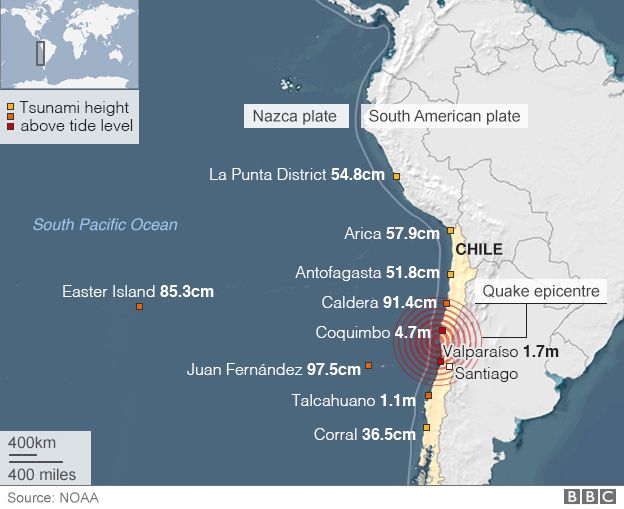

Map: Chile earthquake and observed tsunami heights

The quake lasted for more than three minutes and there have been dozens of aftershocks.
Gloria Navarro, who lives in the coastal town of La Serena, said people were "running in all directions".

At the scene: Jane Chambers, freelance journalist

I'm on the coast about 130km (80 miles) south from the worst affected area of Coquimbo. Our house is on top of a cliff and made of wood. It was shaking and shuddering.
At first I thought it was just a tremor but it was really strong and went on for around three minutes. It was much stronger than any tremors I had ever felt before.
The house is fine as most of Chile's buildings are built to withstand tremors.
The local town was evacuated. The restaurant down on the beach is flooded but most things here are returning to normal.

Officials said 1,800 people in Illapel were left without drinking water.
Electricity providers said hundreds of thousands of their clients in the worst-affected Coquimbo region had no power.


People leave a supermarket during a strong quake in Santiago on 16 September, 2015.Image copyrightAFP
Image captionPeople fled into the streets as the quake caused buildings to sway
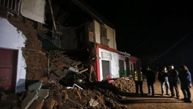
People stand outside a destroyed house in Illapel on 17 September, 2015.Image copyrightAP
Image captionThe city of Illapel was among the worst hit
Bottles lie on the the ground in a shop after an earthquake hit areas of central Chile, in Illapel town, north of Santiago, Chile, September 17, 2015Image copyrightReuters
Image captionThe quake also caused goods to fall from shelves in a supermarket in the city

The US Geological Survey (USGS) said the tremor struck off the coast of Coquimbo, 46km (29 miles) west of the city of Illapel at 19:54 local time (22:54 GMT).
The USGS said it was at a depth of 25km, while Chilean seismologists calculated its depth at 11km.

Analysis: Jonathan Amos, BBC Science Correspondent
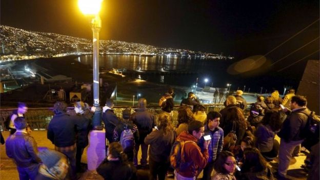


People stand and watch the ocean on Cerro Baron hill, in Valparaiso city on 16 September, 2015,Image copyrightReuters
Image captionResidents of the coastal city of Valparaiso knew to take to higher ground

The quake that rocked Chile on Wednesday was five times more energetic than the one that devastated Nepal back in April. And yet the early indications are that the death toll will be a fraction (perhaps a thousandth) of what it was in the Himalayan nation.
In large part, this is simply down to preparedness. This was Chile's third massive quake in five years; the region all too frequently experiences magnitude 8 events. As a consequence, the building codes are strict and generally well enforced.
What is more, the people themselves are well versed in how to react during and after an event.
It is not perfect. In 2010, an 8.8-magnitude quake witnessed failings on the part of the monitoring network and the system for alerting people to the imminent tsunami threat.
Since then, the Chilean government has spent millions upgrading the country's seismic network of sensors, and made improvements to telecommunications systems that share critical information and warnings.

The earthquake struck as thousands of Chileans were travelling to the coast ahead of a week of celebrations for independence day.
President Michelle Bachelet said some of the official festivities would be cancelled.
The authorities were quick to issue tsunami alerts keen to avert a repeat of the slow response to the 8.8-magnitude quake in 2010, which devastated large areas of the country.
More than 500 people died in that quake and the tsunami it triggered and memories of the tragedy are still raw.


Women remain at a street during a strong quake in Santiago on 16 September, 2015.Image copyrightAFP
Image captionChileans are terrified of a repeat of the deadly 2010 quake and subsequent tsunami
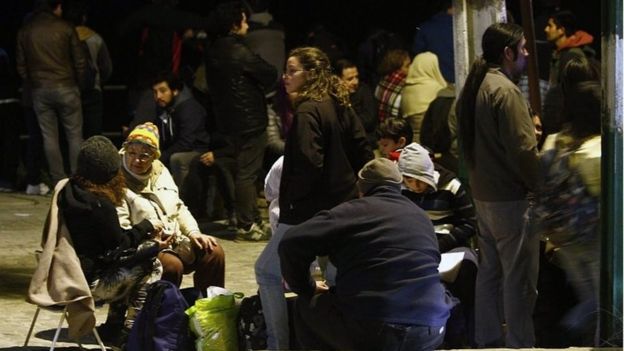
People remain in the street after a tsunami alert in Valparaiso, Chile on 16 September, 2015.Image copyrightAFP
Image captionMany spent the night in the street as aftershocks continued
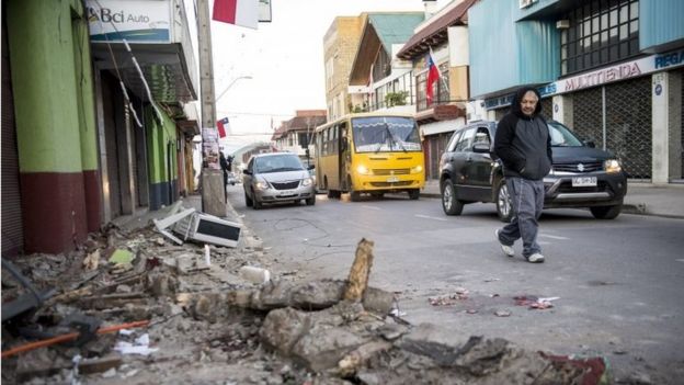
A man crosses a street next to rubble from a collapsed house after an earthquake in Illapel, some 200 km north of Santiago on 17 September, 2015.Image copyrightAFP
Image captionAs day broke, residents began to take stock of the damage

Tsunami alerts were issued shortly after the quake struck for the entire Chilean coast but have been gradually lifted, with the last cancelled at 06:22 local time.
President Bachelet said that "once again we must confront a powerful blow from nature". She will travel to the affected areas later on Thursday.
Chile is one of the most seismically active locations on the globe.
It runs along the boundary between the Nazca and South American tectonic plates. These are vast slabs of the Earth's surface that grind past each other at a rate of up to 80mm per year.

Wednesday, September 16, 2015

20150917 China Daily_Powerful quake hits off coast of Chile, coastal evacuations ordered

SANTIAGO, Chile - A magnitude 8.3 earthquake hit off the coast of Chile on Wednesday, shaking buildings in the capital city of Santiago and generating a tsunami warning for Chile and Peru.
Chile's government urged residents to evacuate the coastline. There were no immediate reports of injuries or damage.
Reuters witnesses said the quake was felt as far away as the Argentine capital, Buenos Aires, on the eastern seaboard of South America.
The quake struck 105 miles (169 km) north of Valparaiso and was originally reported as magnitude 7.9, the US Geological Survey said.
Hazardous tsunami waves from the quake were possible along the coasts of Chile and Peru within the next several hours, the Pacific Tsunami Warning Center said. A tsunami watch was also issued for Hawaii.
If tsunami waves impact Hawaii, the estimated earliest arrival time would be 3:06 a.m. Hawaii Standard Time (1306 GMT) on Thursday, the Pacific Tsunami Warning Center said.
The quake struck at a depth of 15.5 miles (25 km), the USGS said.
Less than an hour after the initial earthquake, three aftershocks all greater than magnitudes 6.1 struck the region, USGS reported.
Chile's state copper miner Codelco said workers at its Ventanas division have been evacuated.

20150915 BBC_Haze chokes Indonesia, Malaysia and Singapore

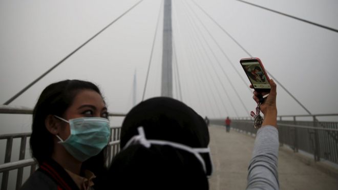
Girls take a selfie on bridge in Pekanbaru, Indonesia (14 Sept 2015)Image copyrightReuters
Image captionThe capital of Indonesia's Riau province, Pekanbaru, has been cloaked in dense haze for weeks
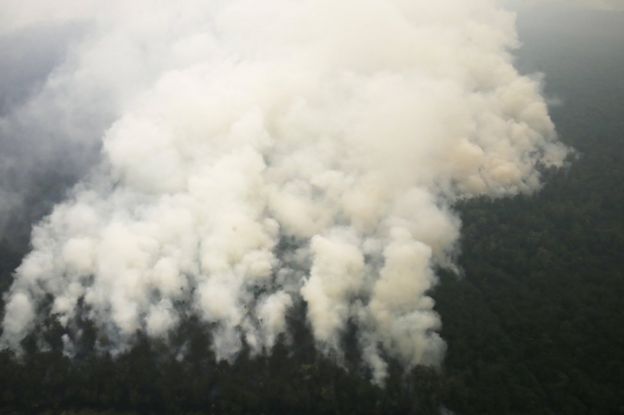
Smoke from huge forest fires in Indonesian has created a cloud of smog over the country, which has spread over neighbouring Malaysia and Singapore.
The fires, which happen every year, are caused by slash-and-burn clearances on the islands of Sumatra and Borneo.
Paper and palm oil companies have been widely blamed for the practice.
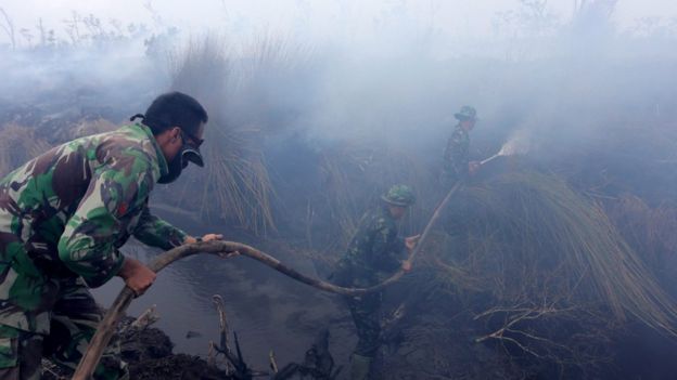
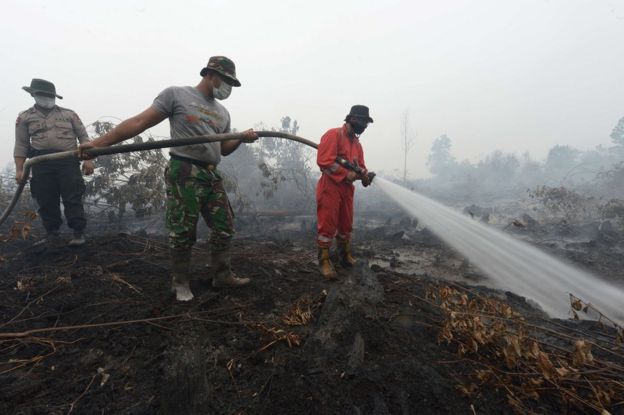
Indonesia, which has repeatedly promised to stop the illegal fires, has sent hundreds of military personnel to try to put them out.
It has declared a state of emergency in Riau province, where the haze has been building for several weeks and pollution levels are hazardous to health.
In Malaysia, schools have been closed in the capital, Kuala Lumpur, and several other areas, while Singaporeans are being advised to avoid strenuous activity outdoors.
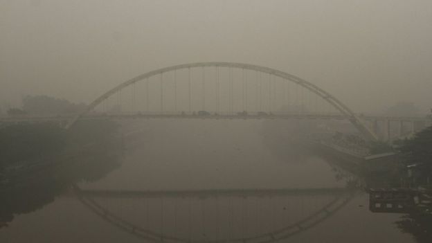
Bridge over the Siak river in Pekanbaru, Riau province, Indonesia (14 Sept 2015)Image copyrightReuters
Image captionMany people have left Pekanbaru but others have struggled on through the haze
Troops hold a hose spraying water on burning shrubs on the Indonesian island of SumatraImage copyrightEPA
Image captionIndonesia has sent around 1,000 troops to fight fires in southern Sumatra
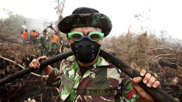
A fire fighter, wearing a mask and swimming goggles to protect himself from the smokeImage copyrightEPA
Image captionIt has promised, and failed, to end the seasonal fires many times in the past
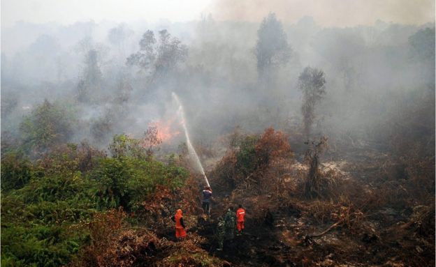
Emergency workers spray a large area of burning forestImage copyrightEPA
Image captionPulp, paper and palm oil companies that own large forest concessions in southern Sumatra are often blamed for illegal fires
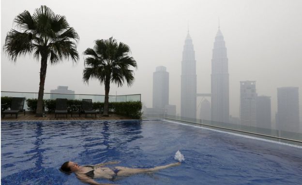
A woman swims in a rooftop pool in front of the Petronas Towers, shrouded by haze, in Kuala LumpurImage copyrightReuters
Image captionIn the Malaysian capital, Kuala Lumpur, there was rooftop swimming under hazy skies
The Malaysian prime minister's office building, shrouded by thick haze on 12 SeptemberImage copyrightEPA
Image captionThe Malaysian prime minister also had to endure the haze, which enveloped his office building
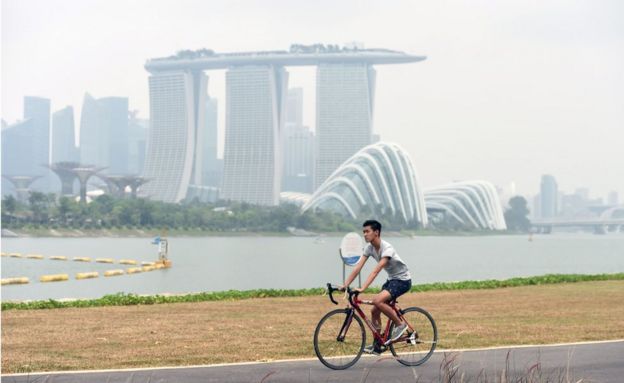
A cyclist cycles through the park at Marina Barrage in Singapore on 14 September, with the skyline blanketed with hazeImage copyrightAFP
Image captionMost - but not all - Singaporeans stayed indoors, as their Environment Agency raised the pollution index to its highest level in a year
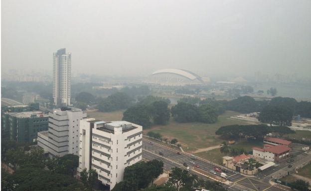
Singapore's National Stadium, barely visible from the BBC's studios in SingaporeImage copyrightSimeon Paterson
Image captionSingapore's National Stadium was barely visible from the BBC's studios
Aerial view of a Singapore Grand Prix 2014 raceImage copyrightGetty Images
Image captionThe haze could obscure all but track-side views at this weekend's Singapore Grand Prix - officials say they are monitoring the situation.http://www.bbc.com/news/world-asia-34242311

20150915 BBC_What causes South East Asia's haze?

Forest fires in Indonesia have resulted in a smoky haze that is blanketing the region and affecting neighbouring Malaysia and Singapore.
The BBC explains what causes the haze, and what makes it such a contentious issue.

What's causing the haze?

Both the haze and the controversy around it have intensified in recent years.
Every year Indonesia sees agriculture fires in Riau province in East Sumatra, South Sumatra, and parts of Kalimantan.
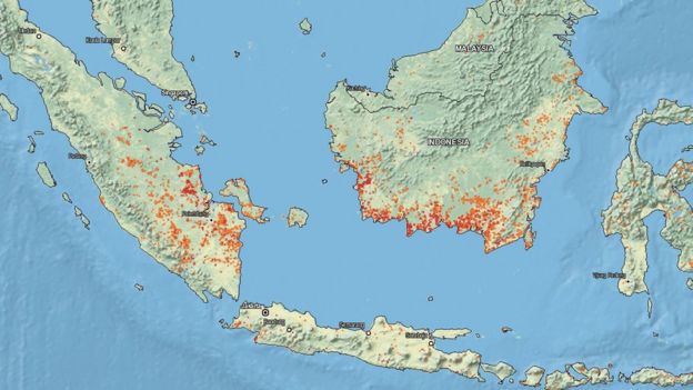
Map from Nasa's satellites showing forest fires in Indonesia from 9 to 16 SeptemberImage copyrightNASA EOSDIS
Image captionNasa satellite data shows multiple fires in mid-September 2015 in the eastern part of Sumatra island and the southern part of Kalimantan island of Indonesia
The fires are said to be caused by corporations in the palm oil, pulp and paper industries, as well as small-scale farmers who use the illegal slash-and-burn method to clear vegetation.
The fires often spin out of control and spread into protected forested areas.
The problem has only accelerated as the cleared land becomes drier, which in turn becomes more highly likely to catch fire the next time round.

Why is it an issue?

The haze gets blown north and westwards across affected Indonesian provinces, as well as towards Malaysia and Singapore, causing a significant deterioration in air quality.
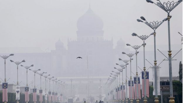
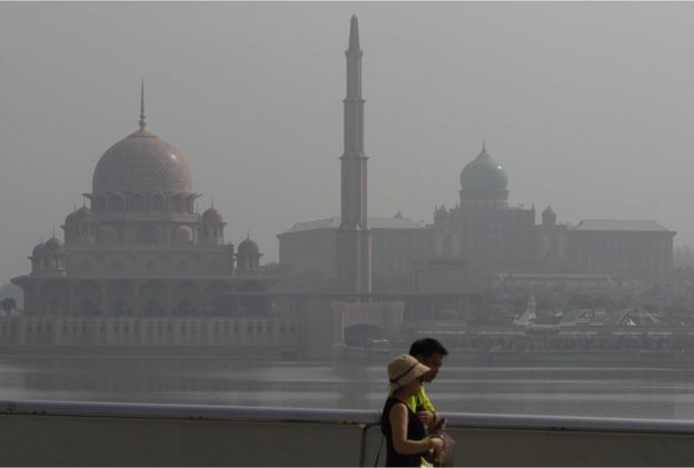
Tourists walk past Putrajaya's iconic buildings, from left to right, Putra Mosque and prime minister's office shrouded with haze in Putrajaya, Malaysia on Wednesday, 16 September 2015Image copyrightAP
Image captionThe haze has blanketed many parts of Malaysia including the centre of government Putrajaya...
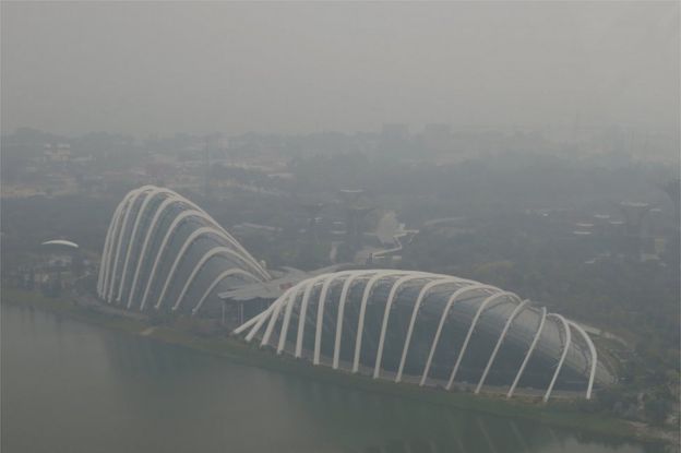
A view of the Flower Dome and Cloud Forest conservatories of Gardens by the Bay and the southern coast of Singapore shrouded by haze in Singapore 10 September 2015Image copyrightReuters
Image caption...and the whole of Singapore, affecting key tourist attractions like Gardens by the Bay
It can be a health hazard, and at its peak it has prompted school closures, flight cancellations and virtual shutdowns of towns and cities.
Singapore and Indonesia use the Pollutants Standards Index (PSI) to measure air quality, while Malaysia uses the similar Air Pollutants Index (API). On both indices, a reading that is above 100 is classified as unhealthy and anything above 300 is hazardous.
Indonesia recently declared a state of emergency in Riau province - one of its towns, Pekanbaru, saw a PSI reading of 984.
Malaysia declared a state of emergency in 2013, when a southern district saw readings of more than 750 API.

What makes it so dangerous?

Besides irritating the respiratory tract and the eyes, pollutants in the haze can cause serious long-term damage to health.
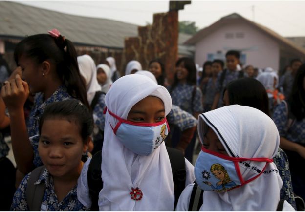
Students, wearing face masks, walk in front of their school as they prepare to head home due to the unhealthy quality of air in Palembang, on Indonesia's Sumatra island, 10 September 2015.Image copyrightReuters
Image captionFace masks have become a common sight in the region
The indices used to measure air quality in the region usually measure particulate matter (PM10), fine particulate matter (PM2.5), sulphur dioxide, carbon monoxide, nitrogen dioxide and ozone.
PM2.5 is considered the most dangerous as it can enter deeper into the lungs. It has been associated with causing respiratory illnesses and lung damage.
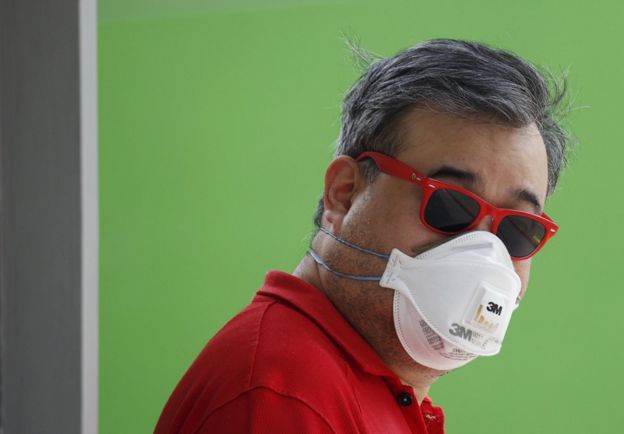
A man wearing a mask for protection against the haze as he waits at a polling station during the general election in Singapore 11 September 2015.Image copyrightReuters
Image captionAuthorities in Singapore have encouraged residents to use special masks that can filter out PM2.5

What is being done to stop it?

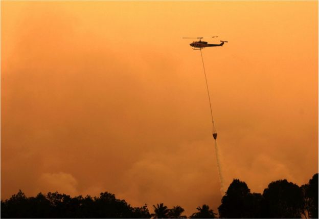
Indonesia has been dumping millions of litres of water in affected areas and has sent in the army to help firefighters put out the fires.
Indonesia and Malaysia have also conducted cloud-seeding to induce rain, while Singapore has pledged assistance to help put out fires.
A helicopter drops water to extinguish a raging fire in Ogan Komering Ilir, South Sumatra Province, Indonesia, 13 September 2015Image copyrightEPA
Image captionHelicopters in Indonesia have been water bombing areas with fires
Indonesia has for years promised to step up enforcement. Under President Joko Widodo, it has named 10 corporations as suspects, and said it is investigating more than 100 individuals.
In 2002, all 10 South East Asian countries signed an agreement to combat the issue through greater monitoring and encouragement of sustainable development, but efforts have been limited.

Why has it been so difficult to stop?

Indonesia has long struggled to police the vast rural expanse in Sumatra and Kalimantan.
An aerial view of smoke rising from a burning forest at Ogan Komering Ulu area in Indonesia's south Sumatra province September 10, 2015Image copyrightReuters
But Indonesia and environment rights activists also say it is not entirely to blame, as some of the corporations accused of illegal burning have Malaysian and Singaporean investors.
Singapore in 2014 passed a set of laws that allow it to prosecute individuals and companies that contribute to the haze, but it remains unclear how this law could be enforced.
There have also been name-and-shame campaigns and calls to boycott the products of the companies said to be contributing to the haze.
Indonesian firemen put out a fire on peatland in Rimbo Panjang, Riau province on 15 September 2015Image copyrightAFP
Image captionDousing out a peat fire is difficult as it can burn underground, and requires swamping the entire area with vast amounts of water
In the meantime Indonesian authorities continue to struggle to put out the fires, many of which have flared up on flammable and dry peat-rich areas.
A peat fire is difficult to put out as it can burn underground for months, and requires a lot of water to extinguish. Fires can spread underground and spring up in other places later.http://www.bbc.com/news/world-asia-34265922

20150916 Telegraph_Volcano Mount Sinabung in Sumatra, Indonesia erupts spewing lava and ash

Slideshow:

http://www.telegraph.co.uk/news/picturegalleries/worldnews/10551746/Volcano-Mount-Sinabung-in-Sumatra-Indonesia-erupts-spewing-lava-and-ash.html