Wednesday, September 16, 2015

20150816 BBC_Montserrat: Living with a volcano


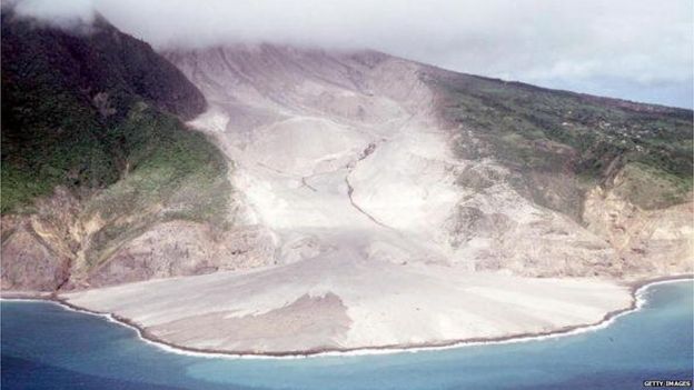
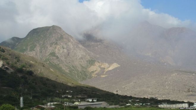
View of Soufriere HillsImage copyrightJanet Edwards
Image captionSoufriere Hills erupted 75 times in a single month in 1997 and is still one of the most active volcanoes in the world

There is little danger of being late for lunch in Montserrat.
At 12:00 sharp every day, the mournful wail of the tiny island's volcano sirens cut through the air like a knife.
The ominous soundtrack to life in this British overseas territory can be heard across inhabited parts of its 100 sq km (39 sq miles).
Residents know if the sirens blare at any moment but noon, it's time to run - fast.
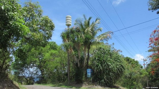
A volcano siren on MontserratImage copyrightJanet Edwards
Image captionVolcano sirens such as this one are tested daily at noon

Taunting in its perpetuity is the steam and bluish haze of sulphur dioxide emitted from the slumbering monster in the south, whose constant threat pervades the atmosphere like a viscous liquid.

Incessant activity

This is the reality for those living in the shadow of Soufriere Hills.
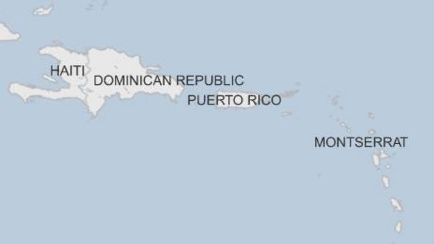
Map of Montserrat

Last month, Montserratians marked 20 years since the start of the volcanic crisis which has rendered two-thirds of the island an exclusion zone, turned the capital city into an apocalyptic movie scene deep in ash and changed life here forever.
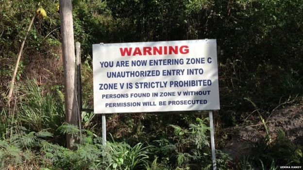
A picture of a poster marking the exclusion zone on MontserratImage copyrightGemma Handy
Image captionTwo-thirds of the island remains within an exclusion zone

Few imagined when a vent in the volcano - dormant for several hundred years - began smoking on 18 July 1995 that it would awaken with such a vengeance.
Or that its incessant activity, rather than the sudden brief explosions favoured by Hollywood, would continue to this day.
Back in the early 90s, Montserrat's future looked bright.
A mammoth cleanup after devastating Hurricane Hugo in 1989 had seen the construction of much modern infrastructure and the territory was experiencing unprecedented prosperity.
There was even talk of independence from Britain.

Fiery spectacle

When the hills first started to emit their brilliant white steam, islanders say it was mesmerising and exciting. People would gather in the evenings to watch the fiery incandescence in awe.
It was 14 months before the first eruption took place in September 1996, sweeping away the villages of St Patrick's and Morris in less than 20 minutes.
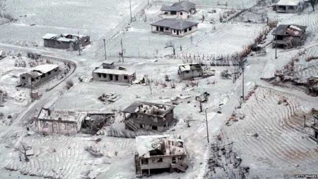
Picture taken on 27 June 1997 showing destroyed houses on the northeast part of Montserrat island after the eruption of the Soufriere Hills volcano.Image copyrightGetty Images
Image captionWhole villages were buried under ash or destroyed by lava flows
View of a lava flow after a blast from the Soufriere volcano on 20 August 1997Image copyrightGetty Images
Image captionA photo from 20 August 1997 shows how lava flows from the volcano covered large areas

That year, the capital Plymouth was evacuated for the final time - abandoned to become slowly buried under repeated mudflows - and a state of emergency declared.
Today, Soufriere remains one of the most active volcanoes in the world.
The population has plummeted from 11,500 to 5,000 with the south of the island divided into five zones.
Permission to access them is dependent on the current hazard level.

Strong bonds

Over the years, businesses have rebuilt in the north, municipal offices have relocated to Brades and the government has created new housing at Lookout, Davy Hill, Shinlands, Drummonds and Sweeneys.
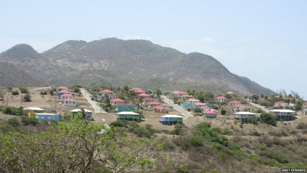
View of new government housing in LookoutImage copyrightJanet Edwards
Image captionThe government has built new housing in Lookout in the north-east of the island

Despite the gases and ash falls - which occasionally reach as far as Antigua - Montserrat's stoic inhabitants largely go about their business unperturbed, refusing to be defined as living on the precipice of peril.
Tourists are politely told that "Montserrat is not a volcano; it has a volcano" and assured that the north remains entirely safe, with Soufriere under round-the-clock monitoring by a purpose-built observatory.
As is often the way in the aftermath of disaster, the close-knit community has forged stronger bonds than ever.
Crime is a rarity, front doors are unlocked, songs of hope and healing, solidarity and unity, are ubiquitous.
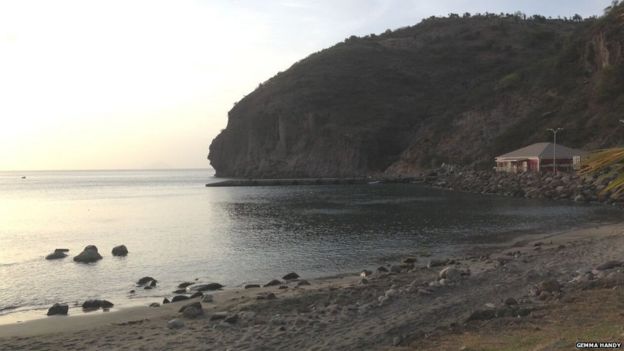
A picture of a Image copyrightGemma Handy
Image captionThe island's distinctive "black sand" beaches get their colour from minuscule pieces of lava

These days, the "emerald isle" is carving a niche for itself in adventure tourism with holidaymakers attracted to its "black sand" beaches and the allure of experiencing a modern-day Pompeii.

Future plans

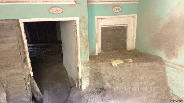
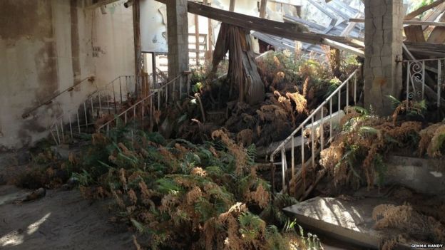
In the ruined Montserrat Springs hotel - once one of the island's finest - visitors can scrabble through the ash into the reception where paperwork still sits on the desk and into bedrooms where curtains hang against wrecked walls.
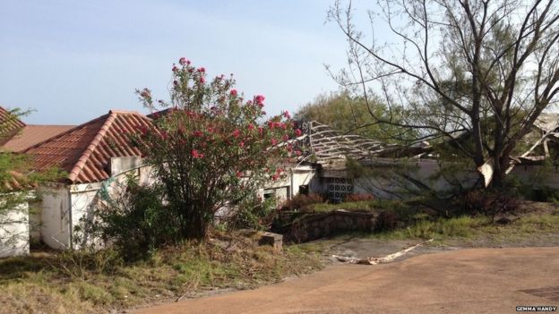
A picture of Montserrat Springs hotelImage copyrightGemma Handy
Image captionMontserrat Springs hotel was once the jewel in the island's tourism crown
A picture of the inside of the Montserrat Springs hotelImage copyrightGemma Handy
Image captionAsh still covers the inside of the rooms
Plants can be seen growing inside the ruins of the Montserrat Springs hotelImage copyrightGemma Handy
Image captionVegetation has taken hold in some of the formerly elegant rooms

From the side of the ravaged swimming pool, Plymouth is visible just east of a huge fissure which appears in the desolate landscape like a jaw wide open in astonishment.
Veronica Hickson's house is one of the few in Plymouth that's not completely buried.
She recalls the evacuation order that came on 3 April 1996. "I've been back since to see my house," she says. "It's sad but we have to continue our lives."
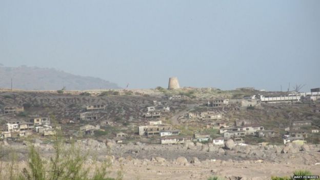
View of PlymouthImage copyrightJanet Edwards
Image captionThe ravaged former capital of Plymouth is visible on the horizon

In addition to tourism, hope for the future lies in geothermal energy exploration and the exportation of volcanic sand for construction.
Islanders are keen to reduce reliance on Britain for financial help - £420m ($655m) since 1995.
Former Governor Frank Savage, who presided over affairs from 1993 to 1997, recently paid tribute to the "stoicism" of Montserratians and their "indomitable spirit" which he said would lead to ever greater recovery.
New Governor Elizabeth Carriere, who takes up position this month, agrees. "Montserrat's future lies in the hands of its most valuable resource: its people," she said.
"I will work with the island's government to realise a safe, sustainable and prosperous Montserrat."
Ms Carriere added: "Better sea links, tapping opportunity for geothermal energy and improving technological links to the wider world all have a part to play."

20150829 BBC_Kilauea volcano spews out molten lava in Hawaii

Lava from a volcano on Hawaii's Big Island has been spewing out of a newly formed opening.
The Kilauea volcano is one of the most active in the world, and has been erupting non-stop for 32 years.

20150917 BBC_Japanese volcano Mount Aso erupts unexpectedly

A volcano on Japan's main southern island of Kyushu has erupted, sending clouds of black smoke and ash into the air.
Mount Aso, which is a popular tourist spot, is one of the most active volcanoes in the country.
Officials said that there were no reports of any injuries.

Friday, June 5, 2015

20150606 BBC_Malaysia mountain quake: Two dead as survivors attempt to descend


Mount Kinabalu is photographed hours after a magnitude 5.9 earthquake shook the area in Kundasang, Sabah on 5 June
The aftermath of the quake near Mount Kinabalu was captured on camera

Two people have died and more than 100 have been left stranded after an earthquake near Malaysia's highest peak, officials say.
The bodies of a local guide and a 12-year-old Singaporean girl were recovered from Mount Kinabalu, on the island of Borneo, local media say.
The 6.0 magnitude earthquake triggered landslides, trapping 137 climbers on the mountain.
Many have been trying to descend with the help of park rangers and guides.
Police chief Jalaluddin Abdul Rahman confirmed the two fatalities but would not give any further details.
Initial attempts to rescue the survivors, some of whom are trapped under rocks, had to be abandoned because of bad weather. Helicopters were unable to land and the climbing route was made dangerous by rocks and boulders.
Several of those injured have successfully made it down and many more are expected to reach base camp by Saturday morning, according to Sabah Parks director Jamili Nais.
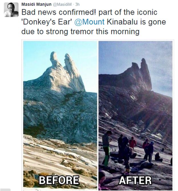
The earthquake was so powerful it also snapped off one of Mount Kinabalu's "Donkey's Ear" peaks.

Tweet

The tourism minister for Sabah state said that 32 guides were assisting the climbers on their way down, with the group moving "cautiously due to (a) damaged trail".
"Other than ongoing rescue efforts, our priority is to send food, drinks and warm clothing to those still stranded on the mountain," he said.
Some of the group had climbed to the summit to watch the sunrise as the earthquake struck.

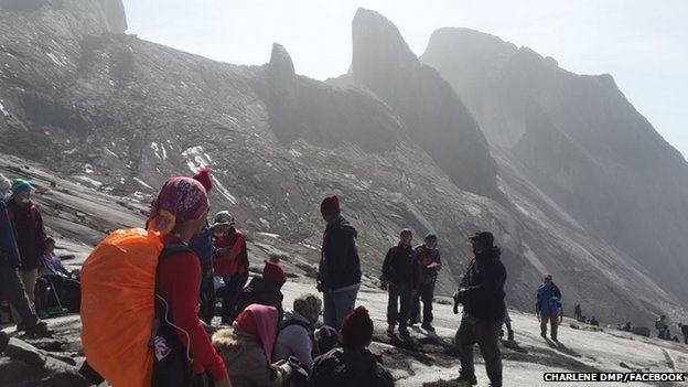
Hikers are trapped on the mountain of Gunung Kinabalu, Sabah state
One Facebook user posted this picture, apparently showing her group stranded
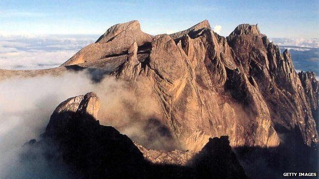
This undated photo shows Mount Kinabalu, South East Asia's highest peak, in East Malaysia's state of Sabah
Mount Kinabalu, which stands at 4,095m (13,435ft), is popular with climbers

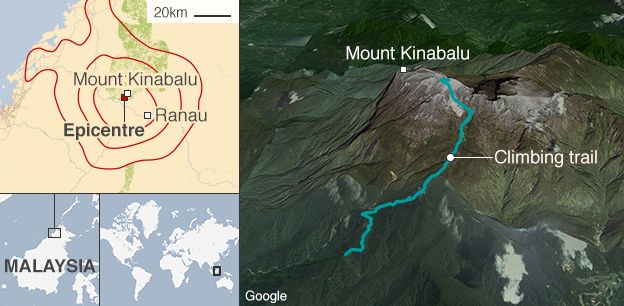
The US Geological Survey said the quake happened at around 07:15 local time (00:15 BST), at a depth of 10km (32,800ft). The epicentre was 54km (33 miles) from Mount Kinabalu, which stands at 4,095m.
Many climbers are attracted to the challenging "via ferrata" climbing route, where cables, metal rungs and bridges are set into the rocks on the steep terrain to help people ascend.
All activity on the mountain has now been suspended.

line
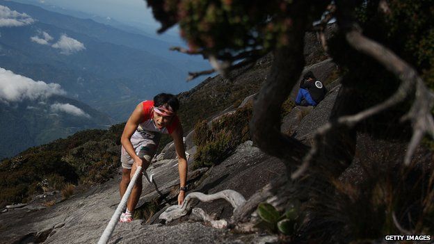
A participant in the Mount Kinabalu Climbathon (October 2013)

Climbing Mt Kinabalu

  • Climbing up and down Mt Kinabalu takes on average two days and one night. There are two trails - the Summit trail and the more advanced Mesilau trail
  • The Summit trail begins at Timpohon Gate (1,800m; 5,906 ft)
  • It takes about 6-8 hours to reach Laban Rata (3,273m; 10,738 ft) where climbers rest for a few hours
  • They usually depart for the summit at 02:00 in the morning, reaching it 4-5 hours later before descending the mountain

line

Earlier, one person apparently trapped on the mountainside said on Facebook:"Currently we're waiting for the helicopter to save us.
"We cannot go down for now because there are lots of stones falling, there's no safe route down, and there are still tremors. Thank you for all your concern and prayers."
The woman identified herself as Charlene Dmp.
The quake also damaged roads and buildings, including schools and a hospital on Sabah's west coast.

A map showing the earthquake that has struck Mount Kinabulu in Malaysia

Wednesday, May 27, 2015

20150527 SCMP_Cheung Chau bun scramble called off as rain sends disappointed festival-goers rushing for ferries

Torrential rain meant the famous Cheung Chau bun scramble was called off last night for the first time since it was revived in 2005 – and that wasn’t the only problem the foul weather caused for the island’s annual holiday festival.
Organisers made the decision to cancel at about 11pm, an hour before the scramble was to begin, sending disappointed festival-goers rushing back to their ferries.
The ritual sees competitors scramble up towers to snatch buns. Organisers decided the midnight race would be too treacherous after the Observatory extended a thunderstorm warning issued earlier.
Watch: Cheung Chau residents parade to celebrate Hong Kong's annual Tai Ping Festival
Contestant and former winner Cheung Man-cheung expressed disappointment that organisers could not make alternate arrangements, such as lowering the 15-metre towers or reducing the three-minute time limit. “We came all the way here and have been training for months,” We all just wanted to compete,” he said.
Yung Chi-ming, director of the festival committee, said the decision was necessary but “very unfortunate”. Student King Tse was disappointed after waiting for hours to watch the scramble, which has its roots in a ritual dating to 1894 to appease the spirits of islanders killed in a plague, but said safety came first.

IN PICTURES: Cheung Chau Bun Festival 2015

The letdown came after a sunny day with temperatures of up to 32 degrees Celsius and only one reminder of the weekend’s wet weather – the stench of rotting buns, which could be smelled from 30 metres away.
“Oh, the buns stink!” was how many visitors reacted as they saw white buns on the towers slowly turning brown. The buns would have been replaced by plastic ones for the scramble.
The highlight of the day was, as always, the Piu Sik afternoon parade, in which hot-button issues were fodder for mockery.
A satirical take on parallel trading at the Piu Sik parade. Photo: Samuel ChanIn a depiction of controversy over cross-border trading, a girl dressed as a rich mainlander stood above another girl, meant to represent Hongkongers. The girl below received falling yuan banknotes, with infant formula and toothpaste lying next to her.
Chu Mei-yan, from a residents’ group that came up with the idea, said: “My message is that mainlanders and Hongkongers should live in harmony,” said Chu Mei-yan, from the group that had the idea.
Ferry operator New World said 48,000 people had travelled between the island and Central by 9pm.

20150527 SCMP_Hong Kong cancels storm signals after 2015's first black rainstorm shuts down city services

Torrential downpours yesterday triggered Hong Kong's first black rainstorm signal of the year, disrupted air traffic and forced schools, courts and government clinics to close.
More than 100mm of rain fell in some areas and 490 flights were affected between 10am and 6pm as the city endured another soaking following a week of storms that saw the cancellation of the Cheung Chau Bun Scrambling Competition.
The black rainstorm warning - the highest of three storm signals - was in place for one hour and five minutes until 11.30am.
An Airport Authority spokesman said five incoming and 12 outgoing flights were cancelled, with 303 incoming flights and 314 outgoing flights delayed.
"Another five incoming flights were diverted to other areas such as Macau, Guangzhou or Haikou in Hainan," he said.
Between 9am and noon, the Observatory recorded more than 4,300 lightning strikes before all rainstorm signals were withdrawn at 12.30pm.
Senior scientific officer Li Sun-wai said the black rainstorm signal was the second shortest of the 19 issued since January 1998. The shortest lasted just 40 minutes on May 8 last year.
Four rainstorm warnings were issued in less than three hours yesterday. At 9.40am, the amber rainstorm signal was issued. This was changed to red at 10am and to black at 10.25am.
"The development of heavy rain was rapid," Li said, with the downpour the result of a trough of low pressure bringing unsettled weather.
"Heavy rain brought more than 70mm of rainfall to urban areas and rainfall even exceeded 100mm over Sha Tin, Tsuen Wan, Sai Kung and Ma On Shan in the morning," he said.
Most government clinics were closed and normal service only resumed in the afternoon.
According to a government spokeswoman, authorities received 15 reports of fallen trees, five reports of flooding and two reports of landslides between 9.40am and 3pm.
Part of the wall of an abandoned house collapsed at Ha Wo Che, Shui Wo Road, in Sha Tin at 10.18am. No one was injured.
Shortly after 11.30am, a section of Sha Tin Pass Road in Wong Tai Sin was closed to traffic following a landslide. It reopened about 3pm.
The rain is expected to ease off towards the end of the week.

20150527 又漏油了:美國雷富希奥洩漏事故

石油洩漏常發生在偏遠的地方,像是墨西哥灣和蒙大拿州的荒地,大家的感受也可能沒那麼深。但當事故發生在有435,000居民的加州聖巴巴拉(Santa Barbara)附近時,憂心忡忡的市民都紛紛趕來關注情況。
Photo by chriscristi
Photo: chriscristi/Instagram
事發於5月19日約上午11時,近雷富希奥州立海灘(Refugio State Beach)的一條石油管道開始洩漏,據管道擁有者Plains All-American Pipeline估計,約105,000加侖的原油可能已溢出,美國海岸警衛隊亦表示,其中有21,000加侖流進了大海,形成兩片共橫跨15公里的油污。石油迅速塗覆海鳥、魚類、甲殼類和其他野生動物,不少已經死亡。
Photo: ccubed61/Instagram
Photo by Scott London
Photo: Scott London/twitter
Photo: David McNew/Getty Images
洩漏的原因仍在調查中,但目前大家都把重點放在清理上。志願者們紛紛湧向海灘,有的甚至親手救出鵜鶘。地方當局警告市民避免前往—石油中含有毒素,其中包括苯(benzene)等已知的致癌物質,但一些熱心人士仍然堅持協助清理。
Photo: C.J. Ward/twitter
Photo: Beth Farnsworth Ward/twitter
近年,美國除了在內陸大力發展石油業,更希望未來幾十年在近海提取更多,從墨西哥灣到中部地大西洋沿岸區甚至風險更高的地方——北極。該國已有4,180,000公里的管道輸送石油,還有更多列車在投入服務。像這樣的事故基本上哪裡都可能發生,但對聖巴巴拉則有更大的意義。這個城市在1969年發生過更大型的洩漏事件,當時在3萬加侖的原油從海上平台滲漏,殺死無數野生動物,亦引發了現代的有關環保運動。